maps
NOTE: SLAB has moved to USC. You can see our latest maps here.
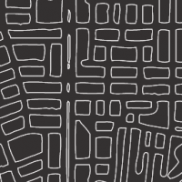
A major ongoing enterprise of SLAB is the development of alternative cartographies, in terms of what we choose to map and the visual representation systems of how we map. What is common about our different map projects is that they seek to show and analyze phenomena that are under-recognized despite being ubiquitous. Our contention is that non-Euclidean metrics are needed because despite being the major space by which people experience Ho Chi Minh City, the area of long, thin individual sidewalks disappear in conventional cartography. New mapping systems are needed to navigate phenomena such as the fluidity of space over time, the social negotiations of space, and the sensorial qualities of space. The maps presented here are works in progress which have raised a number of interesting issues that we are currently exploring.

